

First Principles IAS · Current affairs
The monthly magazine, September 2026 · Environment and Disaster Management › Geological hazards
Printed on · firstprinciplesias.com/current-affairs
Himalayan hazards: lake outbursts and avalanche cascades
LeadPrelims and Mains29 Sep 2026
Why in news
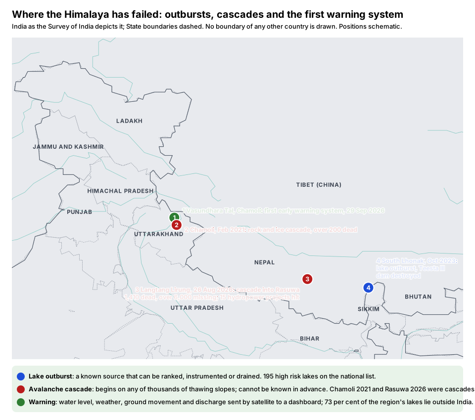
- Uttarakhand began installing its first glacial lake early warning system at Vasundhara Tal in Chamoli on 29 September 2026.
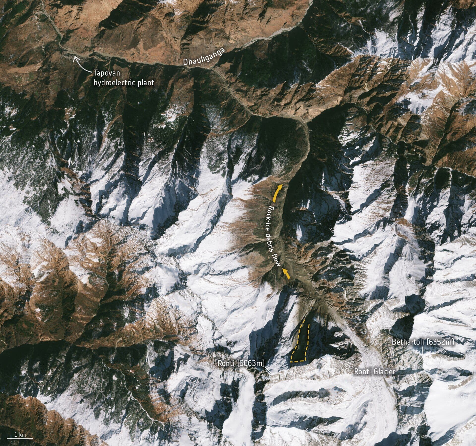
- It comes a month after the Nepal disaster of 26 August, in which ice and rock broke away on Langtang Lirung and ran down the valley as a debris flow, leaving 1,410 dead and over 6,000 missing.
- Experts now say that flow was not a lake outburst at all, which is the point of this article: India is building warning systems for one hazard while the Himalaya produces two.
- 195 high risk glacial lakes on the National Disaster Management Authority's list
- 30 of 100 marks in the Central Water Commission's risk index go to downstream vulnerability
- about 73 per cent of mapped Himalayan glacial lakes lie outside India
- 47 dams that an outburst flood could affect, by the Central Electricity Authority's count
- about 30 minutesthe time a worst case flood set off in Tibet takes to reach the Nepal border
Background
- A glacial lake forms where a retreating glacier leaves a hollow that fills with meltwater, held back by bedrock or by moraine, the loose rock and sediment the glacier leaves behind.
- A moraine dam fails in three ways: by slow erosion, by the melting of ice buried inside it, or when an avalanche or landslide falls into the lake and sends a wave over the top.
- South Lhonak in Sikkim in October 2023, which destroyed the Teesta III dam after a 2019 modelling study had flagged the valley, is the Indian case.
Two hazards, not one
- A glacial lake outburst flood has a known source, the lake, which can be modelled, monitored or drained.
- A rock and ice avalanche cascade can begin on any of hundreds of thousands of steep slopes where permafrost is thawing, so it is far harder to plan for.
- Chamoli in 2021 and Rasuwa in Nepal in 2026 were both cascades, and in both many of the dead and missing were hydropower workers in the path of the flow.
What India has built
- The National Disaster Management Authority keeps a list of 195 high risk lakes, and after South Lhonak approved a National Glacial Lake Outburst Flood Risk Mitigation Programme across Arunachal Pradesh, Himachal Pradesh, Sikkim and Uttarakhand.
- The Central Water Commission tracks water bodies monthly in the monsoon and scores lakes on twelve criteria, giving 30 of 100 marks to downstream vulnerability, because risk is hazard meeting exposure.
- The Vasundhara Tal system tracks water level, weather, ground movement and discharge, and sends data by satellite to a dashboard that raises an alert at set thresholds.
The gaps
- Detection is not warning: the alert has to reach districts, project operators and villages in time, and people act on it only if they trust it.
- The Nepal flow crossed the border with Tibet, and there is no shared data feed across it. The National Remote Sensing Centre's Glacial Lake Atlas finds almost 73 per cent of the lakes in the Himalayan basins outside India, so a warning system that stops at the border misses most of the hazard.
- Black carbon from brick kilns, cookstoves and crop burning darkens snow and speeds melting, and accounts for about a third of Himalayan glacier mass loss.
Analysis
- A hazard you can see and one you cannot. A lake sits in a known place and can be ranked, instrumented and, at a price, drained; a slope that will fail cannot be known in advance, and the 2026 Nepal disaster, like Chamoli in 2021, began on a slope.
- Measure exposure, not sensors: success is how few people and projects sit in the path of a flow. The Central Water Commission's index gets this right in principle.
- Blatten against Chamoli: Blatten in Switzerland in 2025 had one death after evacuation; Chamoli had over 200. Warning is half of it; zoning and local evacuation decide the toll.
- The border is the other half: a country that holds a quarter of the Himalaya's glacial lakes cannot warn itself alone, which turns a disaster management question into a diplomatic one.
The way forward
- Site hydropower and settlements with the cascade hazard in mind, since many Himalayan dams were planned decades ago without knowledge of climate change.
- Share warning data across borders, which India can lead with early warning data from ISRO and a regional risk and insurance facility.
- Cut black carbon at the scale of the airshed, taking kilns, cookstoves, transport and crop residue burning together.
- Fund the warning chain, not only the sensor: sirens, drills and a district protocol that names who acts.
A lake outburst and an avalanche cascade
| Glacial lake outburst flood | Rock and ice avalanche cascade | |
|---|---|---|
| Source | one known lake | any steep, deglaciating slope |
| Trigger | the moraine dam erodes, or a wave from a falling mass breaches it | a slope of rock and ice collapses |
| What can be done | the lake can be modelled, monitored or drained | hard to plan for; siting and land use must change |
| Cases | South Lhonak, 2023 | Chamoli, 2021; Rasuwa, 2026 |
Exam lens
- Prelims: Vasundhara Tal is in Chamoli, Uttarakhand, in the upper Alaknanda basin; Ladakh has the most glacial lakes of any State or Union Territory; the mitigation programme covers four States; permafrost is ground frozen for two consecutive years; peak water is the point after which glacier fed flow declines; the Hindu Kush Himalaya could lose up to 80 per cent of its glacier volume by 2100.
- Mains: "The Himalaya's deadliest floods begin on a slope, not in a lake." Examine India's glacial lake programme in the light of the 2026 Nepal disaster.
Asked before: Mains 2019 GS3 · Mains 2021 GS3 · Mains 2021 GS1
Show the questions
- Mains 2019 GS3: Disaster preparedness is the first step in any disaster management process. Explain how hazard zonation mapping will help disaster mitigation in the case of landslides.
- Mains 2021 GS3: Describe the various causes and the effects of landslides. Mention the important components of the National Landslide Risk Management Strategy.
- Mains 2021 GS1: Differentiate the causes of landslides in the Himalayan region and Western Ghats.
Connects to
- Himalayan glacier retreat (September): the mass loss behind the lakes and the loosened slopes.
- Hydropower in the Himalaya (September): why so many of the dead are project workers.
- Loss and damage (September): Nepal's demand that the big emitters, India among them, pay for the disaster.
Sources
- The Indian Express, 23 September 2026
- The Indian Express, 30 September 2026
- Frontline, 1 September 2026
- Frontline, 30 September 2026
- PIB, 3 September 2026
- Frontline, 7 September 2026, “A warning in the waters”
- The Indian Express, 30 September 2026, “Uttarakhand's first glacial lake early-warning system: What it will monitor, why it matters”
- Frontline, 30 September 2026, “India can see the danger in the Himalaya. Can it manage the risk?”
- The Indian Express, 23 September 2026, “Building trust is key in warnings on melting glaciers”
- The Indian Express, 19 September 2026, “AI can be used to map hazards during disasters like Nepal floods: Kamal Bawa, Founder, ATREE”
- The Indian Express, 17 September 2026, “Why melting glaciers could 'put 20% of India's GDP at risk', and one change that can help”
- The Hindu, 18 September 2026, “Why WFP has called Nepal flood relief one of its toughest missions | Explained”
- The Indian Express, 21 September 2026, “Nepal's climate call is a test for India”
Settled facts (dates of Acts, constitutional provisions, standing definitions) are from standard references.
Filed under: Geological hazards · The monthly magazine, September 2026