

First Principles IAS · Current affairs
The monthly magazine, October 2026 · Environment and Disaster Management › Hydro meteorological hazards
Printed on · firstprinciplesias.com/current-affairs
Cyclone Arnab crosses the Andhra coast near Yanam as the year's first very severe storm
LeadPrelims and Mains28 Oct 2026
Why in news
- Cyclone Arnab crossed the Andhra Pradesh coast close to Yanam in the early hours of 28 October 2026 as a Very Severe Cyclonic Storm, with sustained winds of 125 to 135 km/h and gusts to 150 km/h.
- Arnab was the first cyclone of 2026 in the whole North Indian Ocean basin, the Bay of Bengal and the Arabian Sea together.
- Andhra Pradesh and Odisha moved more than 1,80,000 people out of its path. The India Meteorological Department had put seven Andhra Pradesh districts on red alert.
- The storm moved faster than forecast, and the Department brought the landfall time forward. By that night Arnab had weakened into a deep depression.
Background
How the IMD classes a storm
- The India Meteorological Department classes a storm by its sustained wind. A cyclonic storm blows at 62 to 88 km/h, a severe cyclonic storm at 89 to 117 km/h and a very severe cyclonic storm at 118 to 165 km/h. Arnab sat in the third class.
Why October to December
- The post monsoon months, October to December, are the second peak season for Bay of Bengal cyclones. The sea is still warm, and the strong winds high above the sea that tear a storm apart during the monsoon have gone.
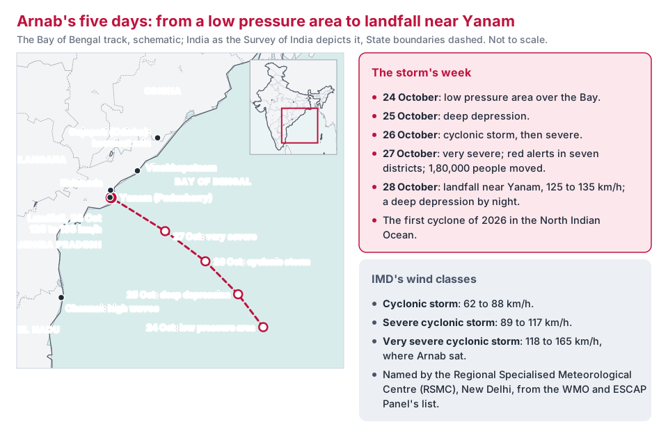
The storm's path and the El Niño link
- In El Niño years cyclones in the North Indian Ocean tend to form closer to the equator. Such storms are then more likely to head for Andhra Pradesh and Tamil Nadu than for Odisha and West Bengal.
- Arnab reached its peak within a day and held that intensity for about six hours after landfall, longer than a storm usually does once it leaves the sea.
- High waves reached north Chennai even though the storm crossed far to the north. Much of southern Odisha had heavy rain, with Gajapati worst hit.
What the storm cost
Andhra Pradesh put its preliminary loss at ₹4,600 crore, with seven deaths. The figure counts the damage, from flooded crop to fallen poles, and shows the first step towards money from the National Disaster Response Fund.
Analysis
India has learned to save lives.
- Odisha's super cyclone of 1999 killed about 10,000 people.
- Odisha now plans every cyclone for "zero casualty".
- Seven deaths after a very severe storm is the result: forecasts, shelters, warnings and buses.
India has not yet learned to save livelihoods.
- The 70,000 hectares of flooded crop and the fallen poles are the loss that the evacuation cannot prevent. Relief pays for the dead and part of the crop.
- A farmer who lost the kharif crop to drought and the rabi sowing to the cyclone carries a loss that no warning insures.
Infrastructure is the weak link.
- Power poles and overhead lines fail in every very severe storm. The 8,000 poles down in Konaseema alone show the scale.
- Underground cables cost more to lay but are the only line that survives a storm of this class.
The two hazards are now one problem.
- Drought and cyclone struck the same districts within a month. Both draw on the same State Disaster Response Fund.
- Disaster finance assumes hazards come one at a time.
The way forward
- Move from wind speed warnings to impact based forecasts that tell a village what the storm will do to its homes, crops and roads. The Department has begun impact based forecasts for some hazards.
- Put coastal distribution lines underground in the worst hit districts, funded from the mitigation window of the disaster funds rather than from relief after each storm.
Exam lens
- Prelims:
- Arnab crossed near Yanam, a part of Puducherry inside Andhra Pradesh, on 28 October 2026, as a Very Severe Cyclonic Storm
- IMD wind classes: cyclonic storm 62 to 88 km/h; severe 89 to 117; very severe 118 to 165
- The WMO and ESCAP Panel on Tropical Cyclones, a group of thirteen countries around the basin, lists the names; the Regional Specialised Meteorological Centre, New Delhi, assigns them
- El Niño years push North Indian Ocean cyclones towards Andhra Pradesh and Tamil Nadu
- October to December is the Bay of Bengal's second cyclone season
- Mains: "India has learned to save lives in cyclones but not yet livelihoods." Discuss with reference to Cyclone Arnab, which struck districts already under drought.
Asked before: Mains 2022 GS1 · Mains 2024 GS1
Show the questions
- Mains 2022 GS1: Discuss the meaning of colour-coded weather warnings for cyclone prone areas given by India Meteorological Department.
- Mains 2024 GS1: What is sea surface temperature rise? How does it affect the formation of tropical cyclones?
Connects to
- Karnataka and Andhra Pradesh declare drought as the El Niño heads for a record (Environment, October): the failed monsoon in the same districts.
- Paying for disasters: NDRF, SDRF and the Finance Commission formula (Environment, August): the funds that the cyclone and the drought both draw on.
- The 2026 monsoon and El Niño (Environment, September): the El Niño that shaped both the monsoon and the storm's path.
Sources
- The Hindu, 24 October 2026
- The Hindu, 26 October 2026
- The Hindu, 27 October 2026
- The Indian Express, 28 October 2026
- The Hindu, 28 October 2026
- The Hindu, 29 October 2026
- The Hindu, 13 October 2026
Settled facts (dates of Acts, constitutional provisions, standing definitions) are from standard references.
Filed under: Hydro meteorological hazards · The monthly magazine, October 2026