Cyclones and coastal hazards
- Syllabus
- Disaster and disaster management
- As of
- October 2026
- tropical cyclone
- IMD classification
- super cyclonic storm
- storm surge
- Odisha model
- zero casualty approach
- multipurpose cyclone shelter
- National Cyclone Risk Mitigation Project
- four stage warning
- impact based forecast
- mangroves
- coastal erosion
- RSMC New Delhi
The first principle
A cyclone kills mainly through water, not wind. The storm surge that pushes the sea onto low coasts and the rain that floods deltas account for most deaths, which is why a cyclone that cannot be stopped can still be made almost harmless by moving people out of the water's path in time. India learnt this at great cost in 1999, so the subject is less about the storm than about the chain of warning, evacuation and shelter that meets it.
The core
How a cyclone forms, in one paragraph
A tropical cyclone is a heat engine fed by warm ocean water, usually above about 26 to 27°C, which evaporates and releases latent heat as it condenses in rising air, deepening the low pressure at the centre. It needs the Coriolis force to spin, so it does not form within about five degrees of the equator, and it needs weak vertical wind shear so that its structure is not torn apart. The full physical geography is in the linked GS1 note on tropical cyclones.
India's exposure
- A long and crowded coast. India's coastline was remeasured in 2025 at 11,098.81 km, up from the older figure of 7,516.6 km because modern mapping follows every inlet; the change reflects better measurement, not new land. Nine coastal States and four Union Territories (UTs), two of them island groups, lie on this coast, and its deltas hold some of the densest rural populations in the country.
- The Bay of Bengal is the main source. The Bay produces about four times as many cyclones as the Arabian Sea, and its northern end, off Odisha, West Bengal and Bangladesh, has a wide, shallow continental shelf and a funnel shaped coast that pile up some of the highest storm surges in the world.
- Two seasons. Cyclones come before the monsoon, in April to June with a peak in May, and after it, in October to December with a peak in November, when the sea is warm and wind shear is low.
- The Arabian Sea is changing. Studies find that Arabian Sea cyclones have become more frequent and more intense in recent decades as that sea warms, so Gujarat, Maharashtra, Goa, Karnataka and Kerala can no longer be treated as low risk.
How the India Meteorological Department classifies them
- By wind speed. The India Meteorological Department (IMD) grades a disturbance by its maximum sustained surface wind, from a depression at 31 to 49 km/h through cyclonic, severe, very severe and extremely severe stages to a super cyclonic storm at 222 km/h or more, as the first figure shows.
- Naming and regional role. IMD's Regional Specialised Meteorological Centre (RSMC) in New Delhi tracks and warns for the whole north Indian Ocean, and cyclones there are named from a list contributed by the 13 member countries of the World Meteorological Organization (WMO) and the United Nations Economic and Social Commission for Asia and the Pacific (ESCAP) Panel on Tropical Cyclones, so warnings are easy to follow across borders.
Dimensions
- Storm surge. A surge is the rise of the sea above the normal tide, pushed by onshore wind and lifted slightly by the low pressure at the storm's centre. It is highest where the shelf is shallow and the coast is funnel shaped, and worst when landfall coincides with high tide, because the two add up to a storm tide that can carry the sea kilometres inland.
- Wind and rain. Very severe winds flatten thatched and mud houses, snap power lines and uproot trees, while the rain that follows a cyclone inland floods rivers far from the coast, so a cyclone is also an inland flood.
- Economic. Saltwater left behind by a surge can make coastal fields unusable for seasons, on top of losses to fisheries, ports and salt pans.
- Social. Fishing families and those in thatched houses close to the sea face the greatest risk, and evacuation has to plan separately for women, children, the old, people with disabilities and livestock.
- Environmental. Mangroves and coastal forests absorb wave energy, and a study of the 1999 Odisha cyclone found fewer deaths in villages sheltered by the Bhitarkanika mangroves. At the same time about a third of India's coast is eroding, which brings the sea closer to settlements before any storm arrives.
- Climate. Warmer seas, higher sea level and rapid intensification, in which a storm strengthens sharply within a day, make surges more dangerous and forecasting harder, as the climate change impacts note explains.
In practice
The Odisha model
- The 1999 super cyclone. On 29 October 1999 a super cyclone with winds of about 260 km/h struck near Paradip in Odisha, and its storm surge and floods killed about 10,000 people, most of them in Jagatsinghpur district. There were few shelters, warnings did not reach villages and no State body was in charge of disasters.
- What Odisha built. The State set up the Odisha State Disaster Management Authority (OSDMA) in December 1999, the first such body in India, and later the Odisha Disaster Rapid Action Force. It built hundreds of multipurpose cyclone shelters on raised ground, run by village committees that keep keys, equipment and lists of vulnerable families, and it installed sirens along the coast. Its rule is that everyone in the danger zone moves before landfall, which is often called the zero casualty approach.
- Phailin, 2013. Cyclone Phailin struck near Gopalpur on the night of 12 October 2013 with winds above 200 km/h, but more than a million people had been moved to shelters and safer buildings, and fewer than 40 died, according to the World Bank.
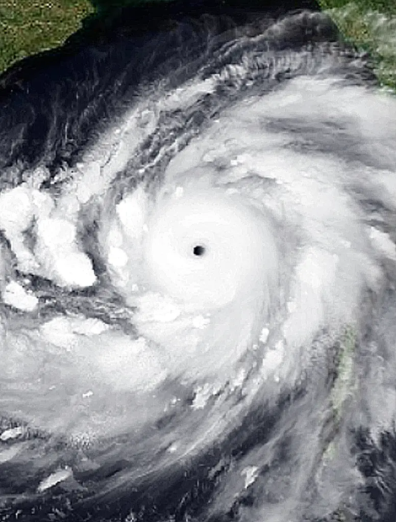
- Fani, 2019. Fani, an extremely severe cyclone of the rare pre monsoon kind, struck near Puri in May 2019. Close to 1.55 million people were moved, using 9,177 shelters including 879 multipurpose cyclone shelters, and deaths stayed in the dozens despite huge damage to houses and power lines.

Other cases
- Amphan, 2020. Amphan became a super cyclonic storm over the Bay of Bengal and crossed the West Bengal and Bangladesh coast across the Sundarbans on 20 May 2020, with sustained winds of 155 to 165 km/h. IMD warned of a surge of 4 to 5 metres in the 24 Parganas districts. Evacuation had to be carried out during the Covid lockdown, and breached earthen embankments in the Sundarbans let seawater into fields, showing that coastal embankments and mangroves are the first line of defence.
- Biparjoy, 2023. Biparjoy, a long lived Arabian Sea cyclone, made landfall near Jakhau port in Kutch on 15 June 2023. About one lakh people were moved to shelters, and the government reported no deaths in Gujarat from the cyclone, showing that the Odisha approach can be carried to the west coast.
Warnings, shelters and the national project
- The four stage warning. IMD issues a pre cyclone watch about 72 hours ahead, a cyclone alert at least 48 hours ahead, a cyclone warning with the expected landfall point at least 24 hours ahead and a post landfall outlook at least 12 hours ahead, with the alert, warning and outlook colour coded yellow, orange and red.
- Impact based forecasts. IMD's bulletins now say what the wind and surge are likely to do, such as damage to thatched houses, power lines and standing crops, and what action to take.
- National Cyclone Risk Mitigation Project (NCRMP). The Ministry of Home Affairs runs this World Bank supported project through the National Disaster Management Authority (NDMA) and the States. Phase I, started in 2011 in Andhra Pradesh and Odisha, built 219 multipurpose shelters in Andhra Pradesh and 316 in Odisha, along with roads, saline embankments and siren based early warning dissemination systems. Phase II, approved in 2015 for Goa, Gujarat, Karnataka, Kerala, Maharashtra and West Bengal, had an outlay of about Rs 2,361 crore.
- Guidelines and law. The NDMA's Guidelines on Management of Cyclones (2008) set out warning, shelters, coastal shelterbelts and mangroves, and the Coastal Regulation Zone rules limit building near the shore.
Issues and way forward
- The last mile and the last house. Warnings reach districts reliably, but fishing boats at sea, migrant workers and people without phones can still be missed, so cell broadcast alerts, sirens, radio and village volunteers must work together.
- Shelters age and fall out of use. A shelter used once in a few years decays unless it doubles as a school or community hall with a maintenance fund, which is why the NCRMP model of village committees and normal time use matters.
- Housing is the hidden loss. Even when lives are saved, thatched and mud houses are flattened, so programmes for cyclone resistant housing and insurance must follow the success in evacuation.
- The coast itself is retreating. Erosion, sand mining and loss of mangroves bring the sea closer each year, so mangrove and shelterbelt planting and strict enforcement of coastal zoning protect more cheaply than walls.
- The west coast must catch up. States on the Arabian Sea have fewer shelters and less practice, so the shelters, drills and volunteer networks of Odisha and Andhra Pradesh need to be built there before a major landfall rather than after.
Common confusions
- Storm surge and tsunami. A storm surge is raised by a cyclone's wind and low pressure and lasts hours around landfall, while a tsunami is a series of long waves set off by a sudden movement of the sea floor, usually an earthquake, and can arrive with no storm at all.
- Storm surge and storm tide. The surge is the rise caused by the storm alone, while the storm tide is the surge added to the normal astronomical tide, which is why landfall at high tide is so dangerous.
- Cyclone alert and cyclone warning. An alert, at least 48 hours ahead, tells authorities to prepare, while a warning, at least 24 hours ahead, gives the landfall point and is the signal for evacuation.
- Severe and super cyclonic storm. A severe cyclonic storm has winds of 89 to 117 km/h, while a super cyclonic storm has winds of 222 km/h or more; the word severe is only the third step on IMD's ladder.
For the exam
- Keyword bank: storm surge, storm tide, super cyclonic storm, four stage warning, impact based forecast, Odisha model, zero casualty approach, multipurpose cyclone shelter, National Cyclone Risk Mitigation Project, mangrove bioshield, coastal erosion, rapid intensification, RSMC New Delhi, last mile connectivity.
- Previous year questions: Practise the previous year questions on this topic →
- Use in an answer:
- Introduction with data: The 1999 super cyclone killed about 10,000 people in Odisha, while Cyclone Phailin in 2013, of similar strength, killed fewer than 40 because more than a million people were moved in time.
- Introduction with a guideline: The NDMA's Guidelines on Management of Cyclones (2008) place early warning, shelters and coastal bioshields at the centre of cyclone risk reduction, rather than relief after landfall.
- Conclusion: India has shown that cyclone deaths can be brought close to zero; the next task is to protect houses, power and livelihoods as well as lives, and to carry the Odisha model to the warming Arabian Sea coast.
- Conclusion: A cyclone cannot be stopped, but its storm surge can be met with warnings, shelters and mangroves, which together turn a natural hazard into a manageable event.