Earthquakes, tsunamis and landslides
- Syllabus
- Disaster and disaster management
- As of
- October 2026
- seismic zoning
- zone factor
- IS 1893
- IS 13920
- IS 4326
- National Building Code 2016
- soft storey
- non engineered construction
- Indian Tsunami Early Warning Centre
- Tsunami Ready
- landslide susceptibility mapping
- Landslide Atlas of India
- debris flow
- retrofitting
The first principle
Earthquakes do not kill people; buildings do. The ground shakes for less than a minute, and almost every death comes from a wall, a roof or a hillside that falls on someone, so the safety of a place depends less on how strong its earthquakes are than on how it builds and where. Earthquakes and landslides cannot be predicted, so management rests on zoning, codes and land use, while tsunamis, which travel for minutes to hours after the quake, are the one hazard in this family that warning can beat.
The core
The mechanism, in one paragraph
The Indian plate is pushing north into the Eurasian plate at a few centimetres a year, and the strain stored in the rocks along the Himalayan thrusts and other faults is released suddenly as an earthquake when the rocks slip. Earthquakes also strike inside the plate, far from its edges, as at Latur and Bhuj. Magnitude measures the energy released at the source on a logarithmic scale, so each whole step means roughly 32 times more energy, while intensity measures the shaking and damage at a given place. A tsunami follows when an undersea quake lifts the sea floor and the water above it, and a landslide is the movement of rock, debris or earth down a slope when rain, shaking or cutting overcomes its strength.
Seismic zoning
- Four zones under IS 1893. The Bureau of Indian Standards (BIS) divides India into seismic zones in IS 1893 (Part 1), the code for earthquake resistant design, whose current version dates from 2016. There are four zones, II to V, each with a zone factor that a designer uses to calculate earthquake forces, ranging from 0.10 in Zone II to 0.36 in Zone V. About 59 per cent of India's land lies in Zones III to V.
- Zone I was dropped after Latur. Latur lay in the lowest zone when it was struck in 1993, so the 2002 revision merged Zone I into Zone II, accepting that no part of India can be treated as free of earthquakes.
- The 2025 revision and its withdrawal. In November 2025 BIS notified a revised IS 1893 (Part 1) based on a probabilistic seismic hazard assessment, which added a new Zone VI covering the Himalayan belt and placed about 61 per cent of India's land in areas prone to moderate to strong shaking. In March 2026 BIS withdrew it after the Ministry of Housing and Urban Affairs raised technical and financial concerns and builders complained of higher costs and too little consultation, so the 2016 code and its four zones remain in force.
- Where the zones lie. The map itself is in the GS1 note on earthquakes and tsunamis; the first figure gives the zones with example regions and cities.
Building codes
- The design codes. IS 1893 sets the earthquake forces a building must resist, IS 13920 (revised 2016) sets the ductile detailing of reinforced concrete so that beams and columns bend without breaking, and IS 4326 (revised 2013) covers earthquake resistant construction, including masonry measures such as horizontal seismic bands at plinth, lintel and roof level.
- The National Building Code. The National Building Code (NBC) 2016, prepared by BIS, gathers structural, fire and planning provisions into one model code. It becomes binding only when States and cities write it into their building bye laws, which is why enforcement varies so widely.
Dimensions
- Construction. A large share of Indian houses, especially in villages and small towns, is built without an engineer, in stone, brick or concrete without proper bands or detailing, so they are the main source of deaths. In cities, buildings with an open ground floor for parking, called a soft storey, collapse because the floor that must resist the most force has the fewest walls.
- Urban. Dense cities in high zones, such as Delhi, Guwahati and Srinagar, combine old buildings, narrow lanes and soft soils, so a single strong quake could cause losses on a national scale.
- Social. The poor live in the weakest buildings and on the most unstable slopes, while schools and hospitals, which must stand after a quake, are often the least maintained public buildings.
- Environmental. Road cutting on steep slopes, quarrying, deforestation and blocked drainage make hillsides fail in the rain, so many landslides are partly made by people.
In practice
Earthquake cases
- Latur, 1993. An earthquake of magnitude about 6.2 struck near Killari in Maharashtra before dawn on 30 September 1993 and killed about 8,000 people, because heavy stone houses with thick mud roofs collapsed on sleeping families. The lesson was that a moderate quake in a region thought safe can be deadly, which led to the revision of the zone map.
- Bhuj, 2001. The magnitude 7.7 earthquake in Kutch on 26 January 2001 killed close to 14,000 people in Gujarat, and multi storey buildings with soft storeys collapsed even in Ahmedabad, far from the epicentre. Gujarat set up the Gujarat State Disaster Management Authority in 2001 and passed the first State disaster management law in 2003, and its owner driven reconstruction, which fed into the national Disaster Management Act of 2005, is still a model.
- Sikkim, 2011. A magnitude 6.9 earthquake on 18 September 2011, near the Sikkim and Nepal border, triggered many landslides and killed over a hundred people across the region. It showed that hill towns face shaking and landslides together.
The 2004 tsunami and the warning centre
- The disaster. On 26 December 2004 a magnitude 9.1 earthquake off northern Sumatra sent a tsunami across the Indian Ocean, and in India it killed more than 10,000 people, mostly in Tamil Nadu, where Nagapattinam was worst hit, and in the Andaman and Nicobar Islands. There was then no warning system in the Indian Ocean, even though the waves took about two hours to reach the Tamil Nadu coast.
- The Indian Tsunami Early Warning Centre. Set up in October 2007 at the Indian National Centre for Ocean Information Services (INCOIS), Hyderabad, under the Ministry of Earth Sciences, it can issue a bulletin within about 10 minutes of a major earthquake in the Indian Ocean. It uses seismic stations, bottom pressure recorders on the sea floor and tide gauges to confirm whether a tsunami has formed, and it serves as a regional tsunami service provider for the Indian Ocean countries.
- Tsunami Ready communities. In 2020 Venkatraipur and Noliasahi in Odisha became the first Indian villages recognised as Tsunami Ready by the Intergovernmental Oceanographic Commission of the United Nations Educational, Scientific and Cultural Organization (UNESCO), for having evacuation maps, signs and drills, because a warning works only if people know where to run.
Landslides
- Mapping. The Geological Survey of India (GSI), the nodal agency for landslides, estimates that about 0.42 million square kilometres, roughly 12.6 per cent of India's land area, is prone to landslides. It has completed National Landslide Susceptibility Mapping at 1:50,000 scale, is mapping critical areas in more detail, and issues experimental rainfall based landslide forecasts in Darjeeling, Kalimpong and the Nilgiris.
- The Landslide Atlas of India. The National Remote Sensing Centre of the Indian Space Research Organisation (ISRO) released the atlas in 2023, with an inventory of about 80,000 landslides from 1998 to 2022, and ranked 147 districts in 17 States and two UTs by landslide exposure; Rudraprayag and Tehri Garhwal in Uttarakhand ranked highest.
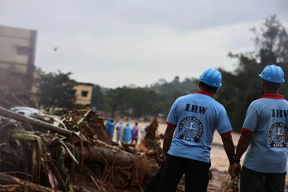
- Wayanad, 2024. In the early hours of 30 July 2024, after days of very heavy rain, a debris flow swept down from the hills above Punchirimattom, Mundakkai and Chooralmala in Wayanad, Kerala, killing more than 200 people, with many missing. Puthumala, in the same panchayat, had seen a deadly landslide only five years earlier. The lesson was that rainfall thresholds must trigger evacuation from mapped slopes, and building on steep Western Ghats slopes must be controlled.

Guidelines
- NDMA guidelines. The National Disaster Management Authority (NDMA) issued Guidelines on Management of Earthquakes in 2007, on Landslides and Snow Avalanches in 2009 and on Tsunamis in 2010, and the National Landslide Risk Management Strategy in 2019. Together they ask for code enforcement, retrofitting of schools and hospitals, microzonation of cities, landslide mapping and early warning.
Issues and way forward
- Codes exist but are not followed. Much construction escapes engineering review, and town planners and municipal engineers rarely check seismic detailing, so the NDMA asks for code compliance to be part of building approval, licensing of engineers and simple guidance for masons.
- Old buildings are the largest risk. New codes do not protect the existing stock, so retrofitting should begin with schools, hospitals and emergency centres, as the NDMA recommends.
- Hazard science versus cost. The withdrawal of the 2025 code shows that stricter zoning raises costs, so a revised map needs consultation, phased adoption and support for small builders rather than being shelved.
- Hill towns are overbuilt. Roads cut without slope protection, buildings on steep slopes and blocked drainage make landslides more likely, so carrying capacity studies, slope stability rules and drainage should govern hill development.
- Landslide warning is young. Rainfall based landslide forecasts are still experimental and regional, so the GSI's system must be extended with rain gauges, soil moisture sensors and clear thresholds that trigger evacuation.
Common confusions
- Magnitude and intensity. Magnitude is a single number for the energy released at the source, while intensity varies from place to place with distance, soil and building quality; one earthquake has one magnitude but many intensities.
- Seismic zone and earthquake prediction. A zone map shows the expected level of shaking over time to guide design, and it does not forecast when an earthquake will strike, which no science can do.
- IS 1893 and IS 13920. IS 1893 tells a designer how large the earthquake forces are, while IS 13920 tells the designer how to detail reinforced concrete so the building survives them.
- Tsunami and storm surge. A tsunami is a series of long waves caused by a sudden movement of the sea floor, while a storm surge is a rise of the sea pushed by a cyclone's wind.
- Landslide susceptibility and landslide risk. Susceptibility is how likely a slope is to fail, while risk adds what lies below it, so a remote unstable slope can carry less risk than a gentler slope above a town.
For the exam
- Keyword bank: seismic zoning, zone factor, IS 1893, IS 13920, IS 4326, National Building Code 2016, soft storey, non engineered construction, retrofitting, microzonation, Indian Tsunami Early Warning Centre, Tsunami Ready, landslide susceptibility, debris flow, rainfall threshold.
- Previous year questions: Practise the previous year questions on this topic →
- Use in an answer:
- Introduction with data: About 59 per cent of India's land lies in seismic Zones III to V, and about 12.6 per cent is prone to landslides, according to BIS and the Geological Survey of India.
- Introduction with a guideline: The NDMA's Guidelines on Management of Earthquakes (2007) start from the principle that earthquakes do not kill, unsafe buildings do, and so place code enforcement and retrofitting at the centre of preparedness.
- Conclusion: India's warning systems have turned tsunamis into a manageable hazard; earthquakes and landslides, which cannot be predicted, demand safer buildings and wiser land use instead.
- Conclusion: From Latur to Wayanad, each disaster has produced a reform, and the task now is to apply those reforms before the next event, not after it.