

20 Nov 2026GS1Topic
Geography: world physical, geophysical phenomena and changing features
Original questions
5 for today1 · First Principles IAS original10 marks150 words
What is a seismic gap? Why does the central Himalayan seismic gap constitute a distinctive hazard for India?
Show the model answerHide the model answer
A seismic gap is a stretch of an active fault that has stayed quiet for long while its neighbours ruptured. Strain keeps building there, making it the likeliest site of the next big quake.
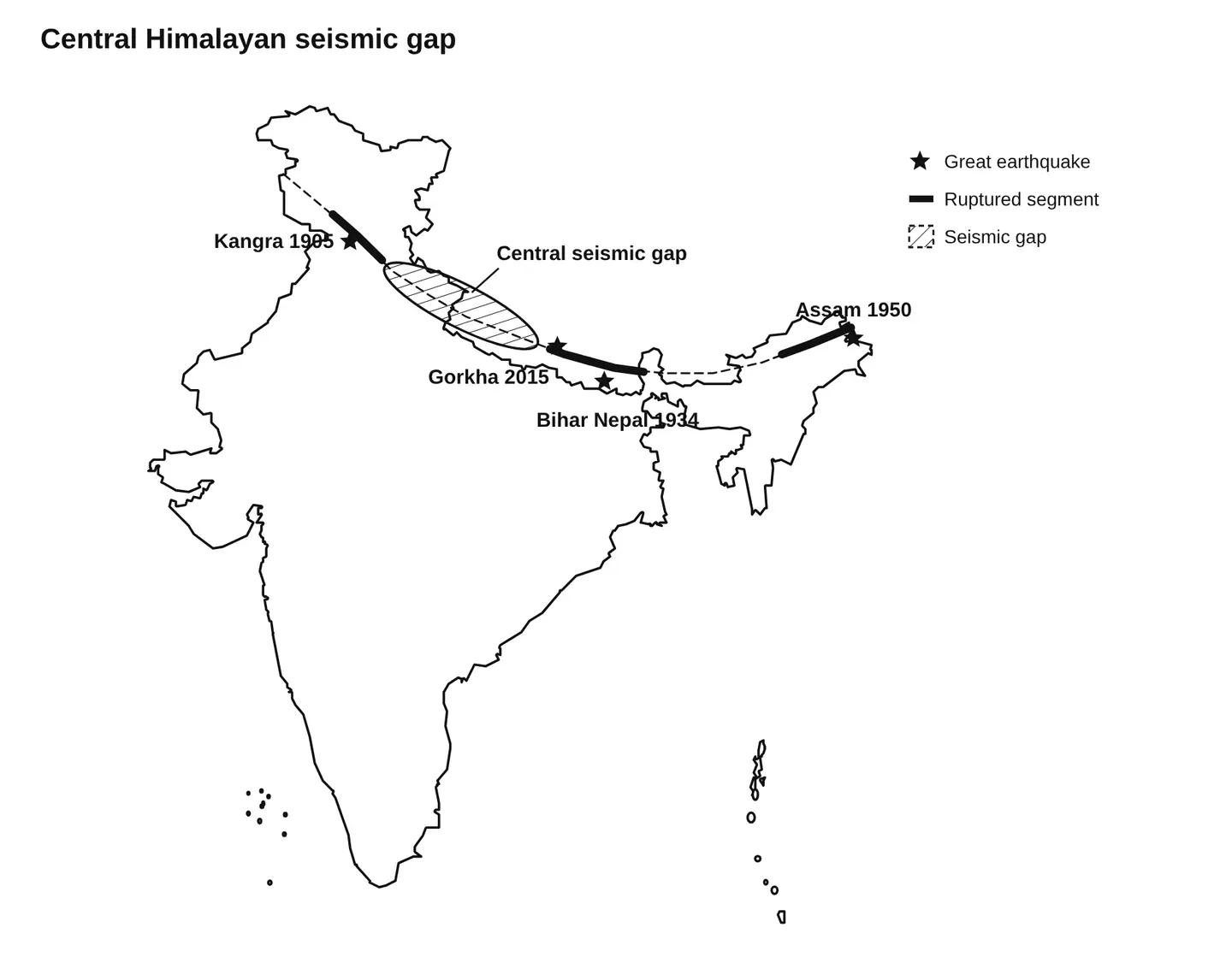
The central gap: The stretch between the Kangra (1905) and Bihar Nepal (1934) ruptures, covering Uttarakhand and western Nepal, has had no great earthquake for about five centuries.
Stored strain: India pushes into Asia at a few centimetres a year. The locked fault may have stored enough slip for an earthquake of magnitude 8 or more.
Why the hazard is distinctive
Dense plains nearby: Shaking would reach the crowded Indo Gangetic plain, where soft alluvium amplifies waves.
Fragile mountains: Steep slopes, dams and glacial lakes could turn one quake into landslides and floods.
Pilgrim crowds: Char Dham routes draw lakhs of visitors into a quake prone zone.
The central gap is a disaster waiting to happen, so preparation must begin long before the ground moves.
Show how the answer was builtHide how the answer was built
Decode
Define a seismic gap and explain why the central Himalayan gap is a special hazard.
Implicit demand
The examiner wants a clear definition, the reason the gap exists, and India specific risks.
Architecture
A definition, a sketch, two points on the gap, three on the hazard, then a verdict.
Articulation
The sketch places the gap between two past ruptures. Money line: preparation before the ground moves.
Show value added materialHide value added material
Facts
Western Nepal earthquake of 1505 is the last great quake in the central gap.
Revised seismic zoning map of the Bureau of Indian Standards places the Himalaya in the highest zone.
Earthquake early warning system in Uttarakhand.
2 · First Principles IAS original10 marks150 words
Explain the formation of karst landscapes. Why are such regions associated with distinctive water management challenges?
Show the model answerHide the model answer
Karst landscapes form on soluble rocks such as limestone and dolomite. Rainwater absorbs carbon dioxide and becomes a weak carbonic acid, which dissolves the rock along joints.
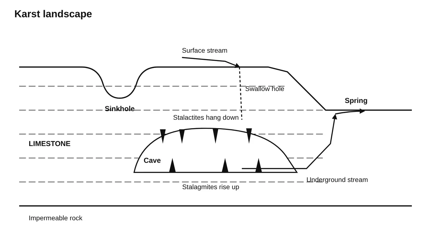
Surface features: Solution widens cracks into sinkholes, swallow holes and dry valleys, as streams disappear underground.
Underground features: Water carves caves, where dripping calcium carbonate builds stalactites and stalagmites. Meghalaya holds some of India's longest caves.
Water management challenges
Surface scarcity: Rain sinks quickly, so rivers and ponds dry up even in high rainfall areas.
Unpredictable aquifers: Water flows through channels, not evenly through rock, so wells often miss it.
Fast pollution: Sewage and mining waste travel quickly without natural filtering.
Collapse and leakage: Pumping can trigger sinkhole collapse, and reservoirs leak through cavities.
Karst regions need water management that follows hidden underground paths, not surface maps.
Show how the answer was builtHide how the answer was built
Decode
Explain how karst forms and why it complicates water management.
Implicit demand
The examiner wants the chemistry, the landforms and specific water problems.
Architecture
A process introduction, a diagram, two points on features, four challenges, then a verdict.
Articulation
The diagram shows why surface water vanishes. Money line: follow hidden underground paths.
Show value added materialHide value added material
Examples
Borra caves in Andhra Pradesh and Kotumsar cave in Chhattisgarh.
Dinaric karst of Slovenia gave the name karst.
Guilin in China and the cenotes of Mexico's Yucatan.
3 · First Principles IAS original15 marks250 words
Distinguish between the mechanisms of tropical and temperate cyclones. Why does India experience only one of the two?
Show the model answerHide the model answer
Both are low pressure systems with winds spiralling inward. They differ in where they form and what powers them.
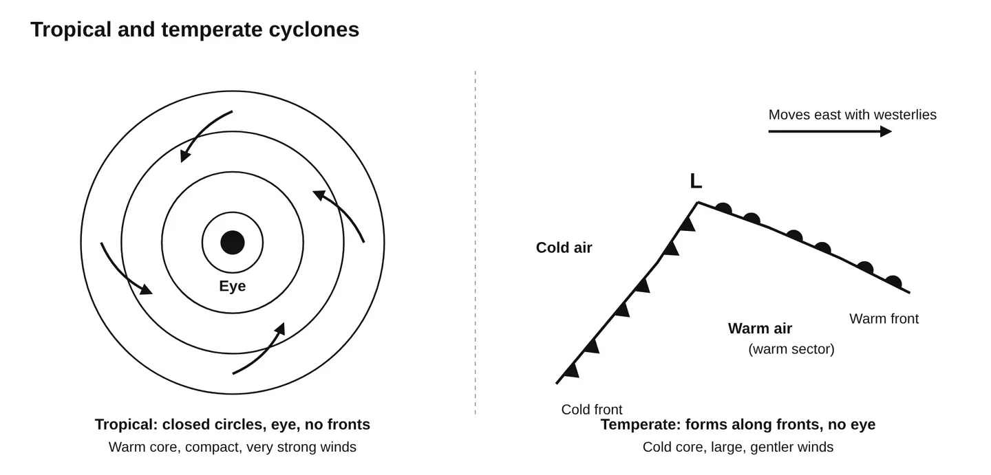
Tropical cyclones
Where and when: They form over warm seas above about 27 degrees Celsius, between roughly 5 and 30 degrees latitude.
Energy: Latent heat released by condensing water vapour drives them. They have a warm core and a calm eye.
Behaviour: They are compact, very violent and move westward with the trade winds. They weaken over land.
Temperate cyclones
Where and when: They form in middle latitudes, about 35 to 65 degrees, along the polar front.
Energy: Contrast between warm and cold air masses drives them. They have warm and cold fronts and no eye.
Behaviour: They are larger, gentler and move eastward with the westerlies, over land and sea alike.
Why India gets only tropical cyclones
Location: India lies in the tropics and subtropics, south of the westerly belt where fronts form.
Warm seas: The Bay of Bengal and Arabian Sea supply the heat and moisture tropical cyclones need.
Himalayan barrier: The Himalaya blocks cold polar air, so the air mass contrast never develops.
Temperate systems reach India only as weakened western disturbances, which bring winter rain to the northwest.
India's latitude and warm seas give it the tropical storm and spare it the frontal one.
Show how the answer was builtHide how the answer was built
Decode
Compare the two cyclone types and explain why India gets only tropical ones.
Implicit demand
The examiner wants side by side mechanisms and a geographic reason for India's case.
Architecture
An introduction, a diagram, three points on each type, three reasons for India, a nuance, then a verdict.
Articulation
Western disturbances add the nuance examiners look for. Money line: latitude and warm seas decide.
Show value added materialHide value added material
Facts
Cyclones do not form within about 5 degrees of the equator because the Coriolis force is too weak.
Bay of Bengal sees more cyclones than the Arabian Sea.
Western disturbances originate over the Mediterranean region.
4 · First Principles IAS original15 marks250 words
Climate change is redrawing the distribution of flora and fauna. Examine with reference to Indian examples.
Show the model answerHide the model answer
Worldwide, species are moving towards the poles and up mountains as temperatures rise. India's varied landscapes show this shift clearly.
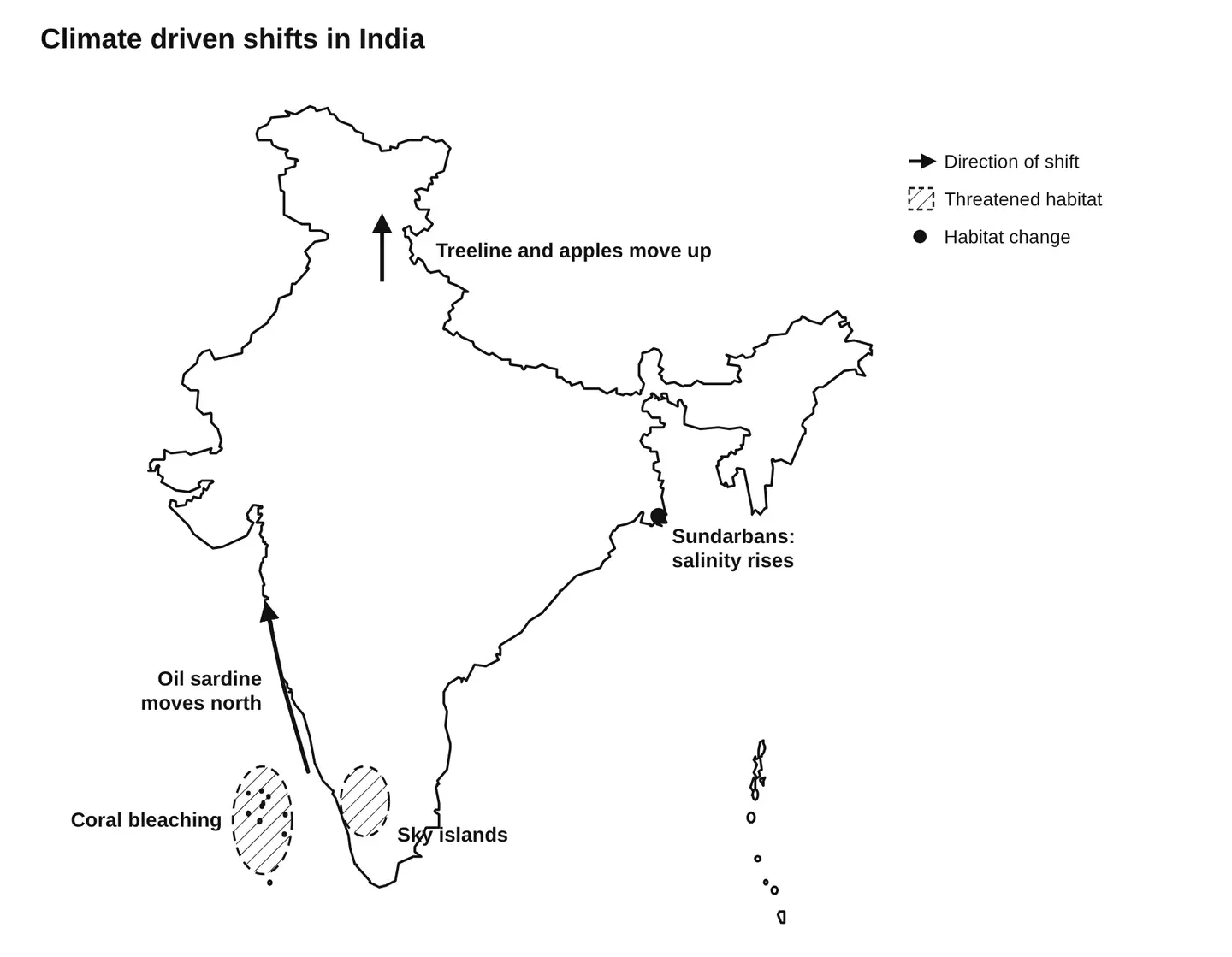
Himalaya moving up: Treelines and plants are climbing higher. Apple orchards in Himachal Pradesh have shifted from lower hills towards Kinnaur and Lahaul.
Sky islands trapped: Species of the Western Ghats shola, such as the Nilgiri tahr, have no higher ground to move to.
Fish moving north: The oil sardine and Indian mackerel have spread north along the west coast and into deeper waters.
Sundarbans: Rising seas and salinity are killing freshwater loving trees such as the sundari.
Coral loss: Repeated bleaching in Lakshadweep and the Gulf of Mannar is reshaping reef life.
Changing seasons: Rhododendrons and mangoes flower earlier, and disease carrying mosquitoes now survive in higher hill towns.
Consequences
Endemic species face extinction, farmers must change crops and human wildlife conflict rises as animals move.
Way forward
Wildlife corridors, protection of high altitude habitats and the National Mission for Sustaining the Himalayan Ecosystem (2010) can help species adapt.
Climate change is redrawing India's living map, and conservation must plan for where species are going, not only where they are.
Show how the answer was builtHide how the answer was built
Decode
Examine how climate change shifts species distribution, using Indian examples.
Implicit demand
The examiner wants several Indian ecosystems, each with a named species or change.
Architecture
An introduction, a sketch, six examples, consequences, a way forward, then a verdict.
Articulation
Apples, sardines and the sundari make the shift concrete. Money line: plan for where species are going.
Show value added materialHide value added material
Facts
Snow leopard and red panda habitats are shrinking.
Green India Mission, 2014.
Species shift upslope by about 11 metres a decade on average worldwide.
5 · First Principles IAS original15 marks250 words
Discuss the causes and consequences of the shrinkage of major inland water bodies of the world.
Show the model answerHide the model answer
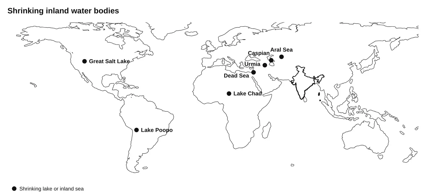
The Aral Sea, once the world's fourth largest lake, has lost most of its water since the 1960s. Lakes and inland seas across the world are shrinking in the same way.
Causes
River diversion: The Soviet Union diverted the Amu Darya and Syr Darya to grow cotton, starving the Aral Sea.
Dams and irrigation: Upstream dams and farming cut inflow to Lake Chad and the Dead Sea.
Climate change: Higher evaporation and weaker rains shrank Lake Poopo in Bolivia, which dried up in 2015.
Groundwater and cities: Pumping and urban demand drained Lake Urmia in Iran and the Great Salt Lake in the United States.
Consequences
Ecological collapse: Rising salinity kills fish and birds, and wetlands disappear.
Toxic dust: Exposed lake beds release salt and pesticide laden dust, harming health around the Aral Sea.
Lost livelihoods: Fishing towns such as Muynak in Uzbekistan now stand far from water.
Conflict and migration: Shrinking Lake Chad has deepened poverty and insecurity across four countries.
Harsher local climate: Without the lake's moderating effect, summers grow hotter and winters colder.
Way forward
The Kok Aral dam (2005) revived part of the North Aral Sea. Efficient irrigation and shared river basin management can save others.
Inland lakes shrink when people take more than rivers can give, and they recover only when that balance returns.
Show how the answer was builtHide how the answer was built
Decode
Discuss why inland water bodies are shrinking and what follows.
Implicit demand
The examiner wants named lakes on several continents, linked causes and consequences.
Architecture
An introduction, a sketch, four causes, five consequences, a way forward, then a verdict.
Articulation
The Aral Sea anchors both causes and consequences. Money line: take no more than rivers can give.
Show value added materialHide value added material
Indian examples
Sambhar lake in Rajasthan is shrinking due to salt mining and encroachment.
Loktak lake faces siltation and invasive phumdis.
Ramsar Convention, 1971, protects wetlands.